DATAMARK® GIS for NG9-1-1

DATAMARK®, the public safety geographic information systems (GIS) business of Michael Baker, is the authority on GIS data for public safety. Its data-forward, full-service but configurable solutions provide the highest levels of public safety GIS data completeness and accuracy needed to support the requirements for any NG9-1-1 system. DATAMARK is supported by Michael Baker’s longstanding GIS services expertise for enabling mission critical call routing, dispatch and response.


LEARN MORE

DATAMARKGIS.com

DATAMARK®’s (SaaS) Solutions

DATAMARK VEP (Validate – Edit – Provision) is a full-service software-as-a-service (SaaS) solution for end-to-end GIS data aggregation, preparation and maintenance for NG9-1-1. Agencies can use DATAMARK VEP to conduct GIS data aggregation and reconciliation for not only its own GIS datasets, but also among neighboring jurisdictions. Using DATAMARK VEP ensures that jurisdictional boundaries are seamless and reconciles NG9-1-1 GIS data with legacy 9-1-1 databases and related GIS datasets.

Technical Services

The DATAMARK team’s depth of expertise in 9-1-1 communications and public safety technology help guide our clients through the NG9-1-1 strategic planning, policy development and governance coordination.

DATAMARK’s expert GIS analysts and subject matter experts work with clients to expand capabilities and accomplish goals. Tasks may include the compiling of a master address database from multiple sources, conducting a validation analysis of the data and providing results for review and approval. Other activities include performing GIS comparisons to determine gaps, evaluating anomalies and determining errors in the data, and providing results for review and approval by a jurisdictional administrator. We work with key stakeholders in developing PSAP and emergency service boundaries.

LEARN MORE

DATAMARK TECHNICAL PDFDATAMARK NON-TECHNICAL PDF

OTMRdata®

LiDAR Data and GIS for Electric Utilities and Communications Providers

Michael Baker’s telecommunication and electric utility products fulfill the requirements for acquiring and analyzing outside plant (OSP) asset data for designing, permitting and constructing electric distribution and 5G networks. Our One Touch Make Ready (OTMR) OTMRdata software products provide cost-effective asset management solutions for electric utility and telecommunications providers. Based on our mobile LiDAR technology, OTMRdata provides easy 360-degree viewing and measurement of utility pole assets and attached cables for pole load models. Data is provided to our customers through our POLEdata.net web-based viewing portal.

POLEmapper® (SaaS) Solution

POLEmapper is a field collection software-as-a-service (SaaS) application for telecommunication and electric utility projects. The system is used to meet the needs of 5G fiber and antenna deployments using field workforce mobile viewing for redlining and editing asset inventory and data collection of poles and aerial cables.

POLEdata® Software

POLEdata.net is our platform-as-a-service (PaaS) solution for viewing collected 3D LiDAR point cloud data, panoramic imagery and GIS data. POLEdata.net enables easy viewing of imagery, GIS data and the LiDAR as a virtual “windshield survey.” For the life-cycle of a project, POLEdata.net allows a single, accurate view for design and construction of outside plant projects.

POLEdata.net® (PaaS) Solution

POLEdata.net is our platform-as-a-service (PaaS) solution for viewing our collected 3D LiDAR point cloud data, panoramic imagery and data extraction products. POLEdata.net enables customers to see both the imagery and the LiDAR as a virtual “windshield survey” while overlaying any GIS or CAD data of utility poles and their attachments. For the life-cycle of a project, POLEdata.net allows both the pole owner, its workforce and OTMR and design-build contractors to have a single, accurate view of the project.

LEARN MORE

Poledata

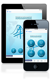
iUSBridges

iUSBridges is a geographic information system (GIS)-based app that allows users to locate nearby bridges, explore details of those bridges, save information on favorite bridges and share feedback.

iUSBridges uses data retrieved from the Federal Highway Administration’s (FHWA) National Bridge Inventory. State departments of transportation provide updated bridge information on a cyclical basis to the FHWA.

Michael Baker designed the application for engineers, department of transportation officials, politicians and hobbyists. The iUSBridges app is free through the App Store. A professional edition is also available.

LEARN MORE

iusbridges.mbakerintl.com
}